UPDATE (09.09.2022): Post substantially revised to reflect v1.0.0 v0.8.0 of the enhanced NYC subway on 08.14.2022. Minor edit and image update made on 08.19.2022. This update adds commentary on the Franklin Avenue shuttle.
In my last post, I discussed the Central Park West redesign. Continuing with point 1 of my three-point plan to improve the NYC Subway (enhance), I’ll address the B, D, N, Q, and R lines in South Brooklyn.
Note: Click any image to enlarge.
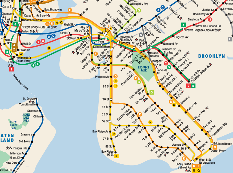
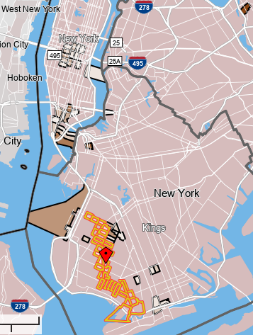
[Fig. 1] Snippet of the NYC Subway map showing the South Brooklyn subway lines.
As Figure 1 shows, many subway lines serve South Brooklyn. NYTIP addresses the B, D, N, Q, and R lines due to their complex interaction throughout the borough. Currently:
- B and D trains cross the Manhattan Bridge on the north side. The B serves the Brighton line and the D serves the 4th Avenue line.
- N and Q trains cross the Manhattan Bridge on the south side. The N serves the 4th Avenue line and the Q serves the Brighton line.
- The R train enters Brooklyn via the Montague Street tunnel and serves the 4th Avenue line.
On the Brighton line, the B runs express and the Q runs local. On the 4th Avenue trunk line, the D and N run express and the R runs local.
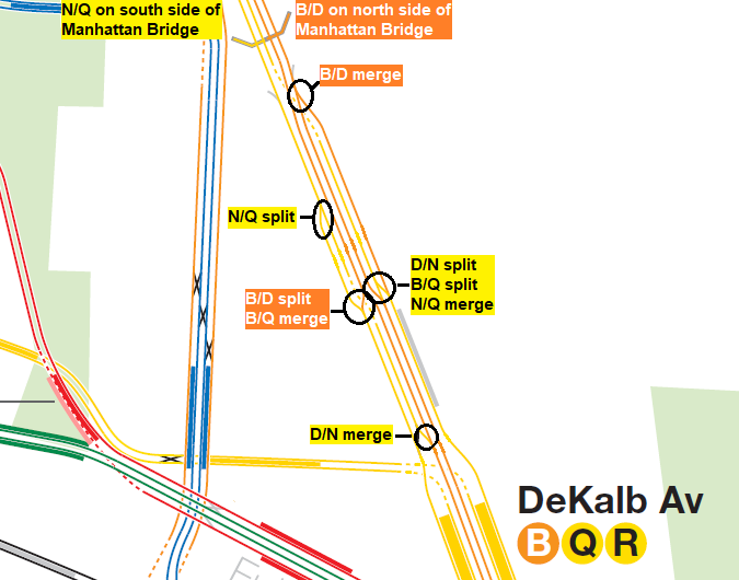
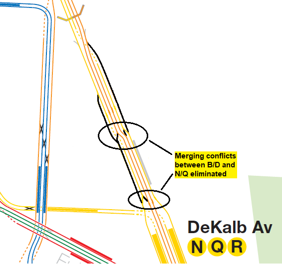
As you can see, there is a lot of interlining here, which causes a lot of problems. The main culprit is the so-called Gold Street interlocking, which controls the switches north of DeKalb Avenue station:
[Fig. 2] Snippet of the NYC Subway track map from vanshnookenraggen showing the complex junction north of DeKalb Avenue.
This interlocking causes a lot of delays for B, D, N, Q, and R riders in Brooklyn – but it doesn’t have to. That’s where NYTIP comes in.
As with Central Park West, several options exist to simplify train movements in South Brooklyn, improving regularity on the B, D, N, Q, and R lines. The key is eliminating merging conflicts at the Gold Street interlocking.
The Easy Way
In previous versions of this post, I considered two simple options that eliminated these conflicts.
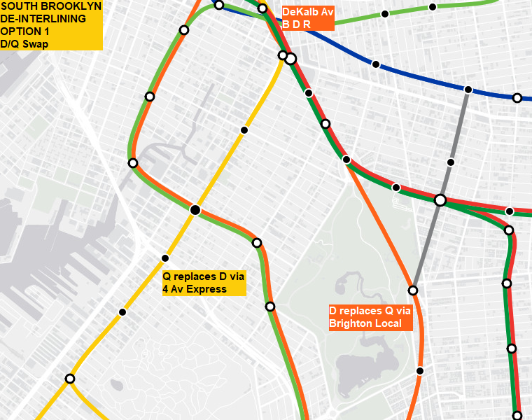
Option 1: Swap the D and Q lines in Brooklyn
[Fig. 3] D/Q swap, northern segment, via Brand New Subway.
[Fig. 4] D/Q swap, southern segment.
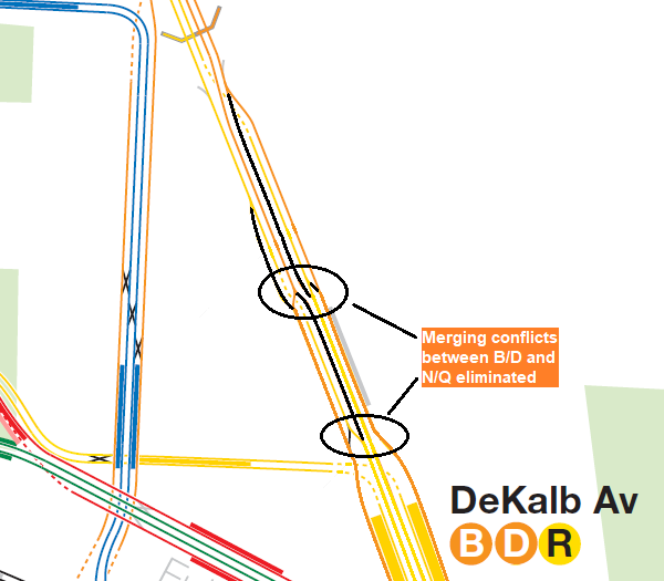
[Fig. 5] Modified track map showing the D/Q swap, which eliminates all merging conflicts.
Option 1 sends the D via the Brighton line to Coney Island, while the Q replaces the D via 4th Avenue and the West End line. This swap eliminates several conflicts between the Broadway and 6th Avenue lines in Brooklyn. While the images above depict a D local, the D could run express to Brighton Beach instead, with the B running local to Coney Island, owing to the longer length of the former.
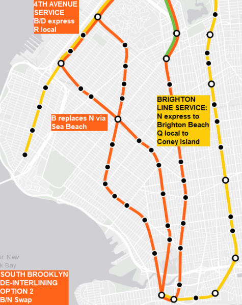
Option 2: Swap the B and N lines
[Fig. 6] Overview of the B/N swap.
[Fig. 7] Modified track map showing the B/N swap, which also eliminates all merging conflicts.
Option 2 sends the B to Coney Island via 4th Avenue express and Sea Beach, while the N replaces the B as the Brighton express to Brighton Beach. The B/N swap also removes conflicts between the Broadway and 6th Avenue lines in Brooklyn.
South Brooklyn Commutation Patterns
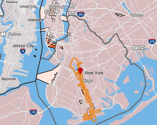
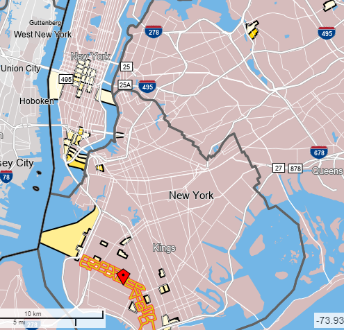
Back in 2004, the MTA surveyed Brighton line riders about their travel preferences and they picked Broadway over 6th Avenue by a near 2-to-1 ratio. If Brighton line riders still prefer Broadway today, then the B/N swap works in their favor. Of course, one must weigh this against 4th Avenue riders’ preferences. As this survey is now 18 years old, I turned to OnTheMap for a second look using the latest available data (2019). I examined the top 50 work destinations among residents living near the Brighton, Sea Beach, and West End lines. Before I present the results, please note two important caveats. First, these are narrow-sense analyses of work destinations by census tract. They do not paint a complete picture of travel patterns – for example, they don’t account for residents who begin their travels from points beyond these census tracts. Second, they don’t account for leisure travel patterns. That said, here’s what I found:
[Fig. 8] Top 50 work destinations for the census tracts surrounding the Brighton line.
[Fig. 9] Top 50 work destinations for the census tracts surrounding the Sea Beach line.
[Fig. 10] Top 50 work destinations for the census tracts surrounding the West End line.
As expected, Midtown, Lower Manhattan, and Downtown Brooklyn stand out to varying degrees as top work destinations, as does Industry City and Williamsburg near Marcy Avenue station. Some local destinations, such as Maimonides Health and other businesses near the West End line, also stand out. Interestingly, Forest Hills makes the top 50 for the Brighton line, while Flushing and Bayside make the top 50 for the Sea Beach line (Flushing also makes the top 50 for the West End line); Flushing and Bayside – along with some neighborhoods along the Sea Beach line – have large Asian populations. Further analyses suggest that the Canal Street corridor is a top-10 work destination for Sea Beach riders, but not for Brighton line riders; to me, this suggests that current N train service along the Sea Beach line provides a sort of lifeline for the various Asian populations in the city.
Importantly, the Broadway and 6th Avenue lines serve similar destinations in Midtown, making them interchangeable with respect to South Brooklyn – either of the aforementioned swaps would thus yield massive improvements. Based on the data presented above, I am inclined to send Broadway services via 4th Avenue and 6th Avenue services via Brighton, which favors the D/Q swap in Option 1. Since the D is longer than the B under NYTIP, the D would run via Brighton express and the B would run via Brighton local.
As a total package, however, this swap simply isn’t enough.
A Better Brighton Line
Originally, both Brighton local and express trains served Coney Island; at West 8th Street – NY Aquarium station, expresses used the upper level while locals took ramps to the lower level. The Culver line connection to Coney Island, built in 1920, resulted in an at-grade merge with the Brighton local tracks. In 1954, the city severed the lower level connection to the Brighton line by removing the tracks; however, the connecting ramps still exist. To prevent merging conflicts, expresses terminate at Brighton Beach, while locals continue to Coney Island. This pattern causes unbalanced ridership between local and express trains.
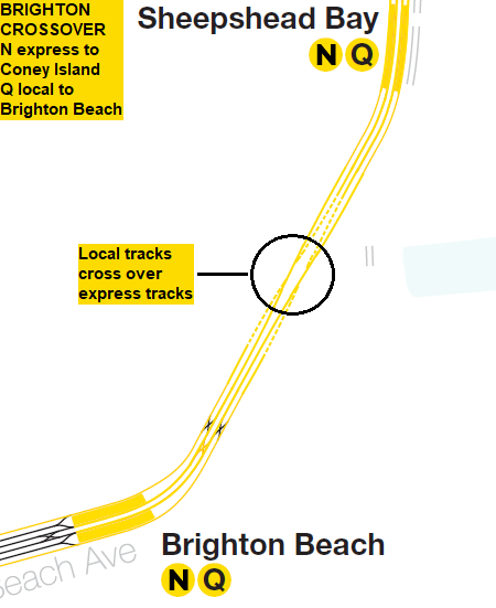
In previous versions of this post, I proposed something called the “Brighton Crossover” to address this issue:
[Fig. 11] Overview of the Brighton crossover. N and Q trains shown for illustrative purposes.
With this flying crossover, Brighton local trains terminate at Brighton Beach and Brighton express trains continue to Coney Island. However, building this crossover would be highly disruptive – and as it turns out, a simpler, less disruptive option exists.
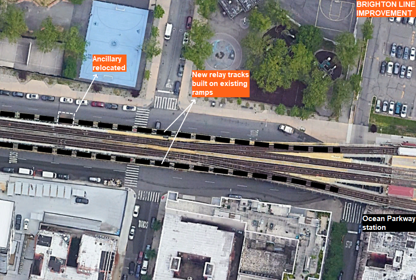
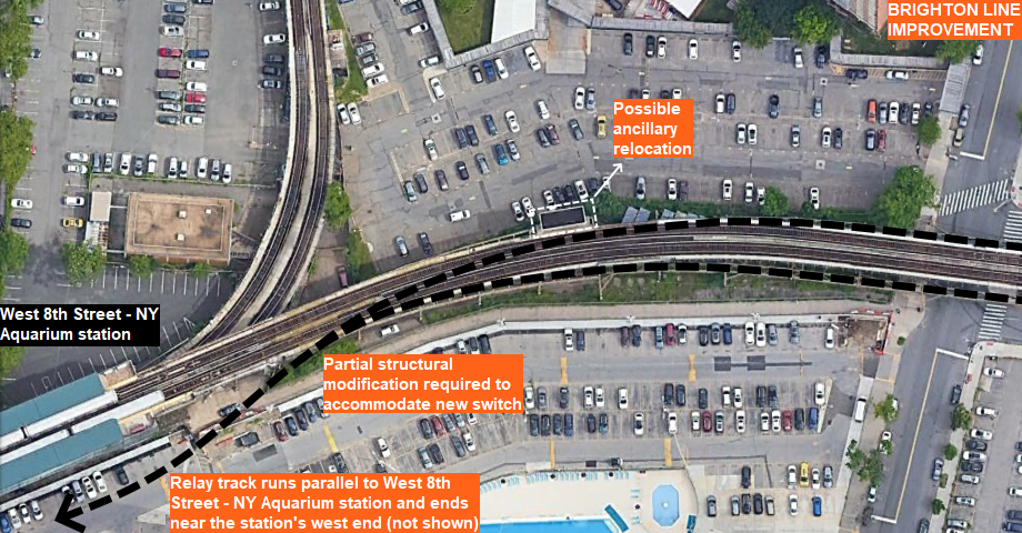
Potential capital investment: Build a relay track using existing ramps west of Ocean Parkway station.
[Figs. 12, 13] Overview of the proposed relay track.
This relay track, which mostly uses existing infrastructure, would allow Brighton local trains to terminate at Ocean Parkway and change directions without interfering with Brighton express service, which would extend to Coney Island. The service increase at Ocean Parkway and the use of existing infrastructure make this relay track a superior alternative to the Brighton Crossover for improving Brighton line service.
The service plan for v0.8.0 of the enhanced NYC subway under NYTIP assumes that this relay track is built, allowing B local service to Ocean Parkway and D express service to Coney Island. If it isn’t built, then the B would run to Coney Island and the D would run to Brighton Beach.
Future-Proofing the 4th Avenue Subway
The suite of service changes contemplated for South Brooklyn must allow for future service increases and subway extensions. The aforementioned CPW redesign and the D/Q swap remove most merges from the B and D; this would allow significant service increases on the Brighton line beyond the current combined 20 trains per hour (TPH) once additional rolling stock becomes available. But what about 4th Avenue and its branches?
With the B and D on Brighton, this leaves the N, Q, and R on 4th Avenue. The N and Q run express and the R runs local. The current R suffers from frequent delays due to merging conflicts in Manhattan and Queens, as well as its length – roughly 21.6 miles! One common suggestion is extending the W to Brooklyn to relieve the R. Interestingly, the MTA’s 20-year Needs Assessment explores a W extension…to Red Hook? Not exactly what I had in mind, but anyway…combined R and W service through Manhattan is limited to 21 TPH due to the City Hall reverse curve. This constraint means that one line would be capped at 11 TPH (~5.5 minute headway), while the other is capped at 10 TPH (6 minute headway).
In any case, extending the W to Brooklyn is not yet possible due to available rolling stock. The earliest opportunity would be after MTA completes the base order and the first option order of the new R211 cars.
But what if we didn’t have to wait that long – and what if we don’t have to cap 4th Avenue local service at 21 TPH?
Closing the Loop
Prior to 2010, the brown M ran from Middle Village in Queens to Bay Parkway in Brooklyn via the Nassau Street loop and the West End line. It was very infrequent – it only ran every 10 minutes, even during rush hours. As part of a series of service cuts in 2010, the brown M was combined with the V, rerouting M trains from downtown to Midtown. This was the only one of those “service cuts” that was actually a net benefit – the M to Midtown was a smash hit, gaining higher ridership than the M to Nassau Street and South Brooklyn did. This left the J as the sole Nassau Street service, and since it only runs to Broad Street, this severed a link between lower Manhattan and South Brooklyn.
As Figure 10 shows, however, there is still a practical use case for a South Brooklyn – Nassau Street – Williamsburg service. This corridor is best served by extending the J to Bay Parkway. While not possible at present, it would be possible as soon as MTA completes the base R211 order; in other words, this is achievable sooner than a combined R/W service.
In v0.8.0, the base R211 order of 440 standard cars and 20 articulated cars would all be assigned to the A train. This would make the A train 100% R211, which allows its 600-foot R179 trains to be reassigned to the C. Each 600-foot R179 train would replace one 480-foot R179 train; consequently, the 480-foot R179 trains removed from the C would be assigned to the J, yielding enough cars for a Bay Parkway extension. This ensures future-proofing in two ways. First, combined 4th Avenue local service could exceed 21 TPH if necessitated by demand. Second, this frees up additional R211 cars for service increases and subway extensions like SAS Phase 2 and the Astoria extension to LaGuardia Airport.
Making the Switch
Some time ago, vanshnookenraggen blogged about a de-interlining plan using switch provisions south of 36th Street station. Incidentally, these switch provisions also lend themselves to future-proofing. Consider the Staten Island Subway proposals. vanshnookenraggen’s excellent two–part post (two separate links) on the Staten Island Subway includes various build alternatives. Given how far Staten Island is from the rest of the city, and given its size (for comparison, the SIR is almost as long as the 1 line!), extending an express train makes the most sense. Vansh’s “one switch” plan is one way to catalyze such an extension.
As applied to NYTIP, using these switch provisions sends all 4th Avenue local service via the West End line. Since this would make the R too long, the R would be truncated to Whitehall Street in Manhattan while the W extends to Coney Island in its place. N express service via the Sea Beach line remains unchanged, while Bay Ridge riders now get a semi-express Q train in place of the R local.
Summary
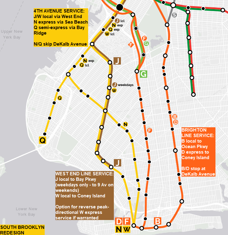
The subways serving South Brooklyn have a rich and complex history that makes service improvements challenging. While a simple swap would address the notorious Gold Street interlocking, version 0.8.0 of the enhanced NYC subway incorporates additional changes that “future-proof” improvements. The proposed service plan is shown below:
[Fig. 14] The enhanced NYC subway in South Brooklyn.
Two capital improvements – new switches south of 36th Street station and a new relay track west of Ocean Parkway station – would facilitate these changes. On the Brighton line, the B runs local to Ocean Parkway and the D runs express to Coney Island. On 4th Avenue, the W replaces the R, and the J and W run local and the N and Q run express; however, the Q runs local south of 36th Street station. On the West End line, both the J and W run local. For operational simplicity, the J would run to Bay Parkway all day on weekdays; however, the J would only run to 9th Avenue on weekends. Reverse peak-directional W express service is possible if warranted by demand. All South Brooklyn lines have direct access to at least one storage yard except the Q; the Q would have indirect access to Coney Island yard via the Sea Beach line, but this is not a major issue since the N and Q run together for most of their length.
Complementary Improvement: Franklin Avenue Shuttle Upgrade
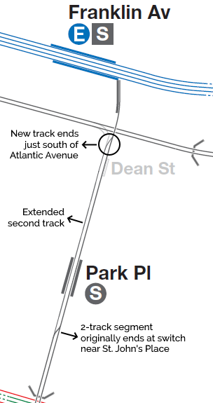
The Franklin Avenue shuttle runs from Franklin Avenue at Fulton Street to Prospect Park on the Brighton line. Except for Park Place, each station on the shuttle connects to other subway lines. MTA rebuilt the shuttle in 1998 due to advanced deterioration and community demand (they originally intended to abandon it); however, the line was rebuilt with just one track north of St. John’s Place. Thus, the Park Place and Franklin Avenue stations are single-tracked. Because of this, the shuttle only runs every 10 minutes at all times. This is too infrequent for a service that connects several subway lines.
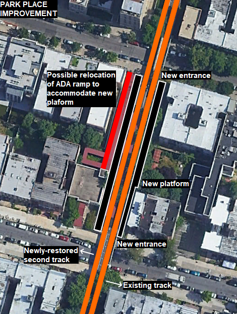
To increase service, the second track needs to be extended. The line originally had two tracks and the space for the second track still exists, so this is feasible. This requires replacing six single-track overpasses with double-track overpasses, building about 2,450 feet of track, building a switch south of Atlantic Avenue (the Fulton Street station would still have one track), and rebuilding Park Place station. The images below show the proposed changes.
[Fig. 15] Overview of the Franklin Avenue shuttle improvement.
[Fig. 16] Overview of the Park Place station rebuild and second track.
The extended 2-track segment would allow significant service increases on the Franklin Avenue shuttle. At Park Place station, the rebuilt platforms would be about 240 feet long; this is a provision for longer trains – the current shuttles use 150-foot trains. While platform extensions at Botanic Garden and Franklin Avenue are not part of this plan, they can be extended later if 60-foot cars replace the R68 cars currently used on the Franklin Avenue shuttle.
The Bottom Line
The South Brooklyn redesign would affect B, D, J, N, Q, R, W, and Franklin Avenue shuttle service. The table below shows current frequencies and proposed frequencies under NYTIP (in minutes) for the J, N, Q, and W lines, as well as the Franklin Avenue shuttle; I previously addressed the B and D in the CPW redesign post, and I will address the R in the Broadway/Queens Boulevard post. (Note: The J and W would each run 10 TPH, or every 6 minutes, in South Brooklyn; the extra J trains – 2 TPH – turn at Broad Street, while the extra W trains – 4 TPH – turn at Canal Street.)
| Service | Current Service (Weekday Peak/Weekday Off-Peak/Weekend) | Proposed NYTIP Service (Peak/Off-Peak) |
| J | 5-10 / 10 / 10 | 5 / 6 |
| N | 7.5 / 10 / 12 | 6 / 6 |
| Q | 6 / 8 / 8 | 6 / 6 |
| W | 7.5 / 10 / – | 4.3 / 6 |
| S Franklin | 10 / 10 / 10-12 | 5 / 5 |


I just read this post again. It occurred to me that you can’t run the W express if you run also run the J to either Bay Pkwy or 9th Ave. Because if the J terminates on the middle track at either station, then it will block West End express W trains. It would either have to be both the J and W making all stops or a (W) local/ express pattern similar to the (6) local/ express pattern in The Bronx.
From what I’ve seen of the track layout, a peak directional express is not impossible; however, trains turning at Bay Parkway have to relay, so locals and expresses would inevitably cross in front of each other – much like the northbound (6) local/express, as you mentioned. In any case, I don’t think there’s enough demand at present, so I’m proposing all-local service for both the J and W here.
Oh wait…now I see how it could be done. If all J’s are local and all’s W are express in the peak direction. That’s doable. For some reason, I assumed both the J and W running local, PLUS a peak express W.
It’s possible there’s not enough demand for a West End peak express. They never did one in all the time the M ran there (1986-2010). Or when the B ran there solo (1967-86). But in all that time, the primary West End service ran express on 4th Ave. If the West End service is going to become the new 4th Ave Local above 36th St, a peak express might be a way to soften the blow for West End riders who would be losing their current D express train for a local train.
If what you’ve discovered from working with OnTheMap is indeed more reflective of how riders on the Brighton, Sea Beach and West End lines are commuting in 2019 vs 2004, then I might reconsider my preference for the B/N swap and for extending the J onto the West End Line. I’ve long been of the belief in Brighton riders’ preference for Broadway and the almost-uselessness of the former M service to Bay Pkwy. Am I correct to assume that the darker shaded areas in Manhattan and Industry City are where more riders are headed?
Yes – for the OnTheMap outputs, the darker the shading, the more people heading to that area.
Remember the caveats though – narrow-sense analysis; doesn’t capture the whole picture, but gives a pretty decent idea. I think vanshnookenraggen also noted an anomaly with the Downtown Brooklyn data in one of his posts.
Truthfully, the former M service *was* lightly used, but a lot has changed in the last 2 decades!
And it may change more when we begin to see periodic closures of the BQE next year.
https://nyc.streetsblog.org/2022/06/27/locals-fear-carmageddon-from-bqe-repair-work/
I wonder if an extended J might come in handy for drivers who will be affected by the closures.
But other than that, I’ve still got my reservations about how well a South Brooklyn-Nassau St line service would be used.
The BQE saga is one giant clusterfuck. They should just tear it down.
Extending the J could certainly bring some relief, as would service increases on the G. And those two lines should have an in-system transfer at Broadway!
Now, I can understand your reservations about restoring the Nassau – SBK service. But I also think about how an infrequent, delay-prone brown M saw some 10,000 daily riders. Maybe you get more with better service.
Due to option 3 in this plan called vansh. I would deal with it. If I said to the conductor “Is the R going to Bay Ridge?”, they said “No”. The B is now serving Bay Ridge, and I punched that conductor during a tantrum, then I would be sued by the conductor and charged. On the B, D, R, Q, or N train, I would not want to sit next to a man who punched a conductor who said “The N is now going to Coney Island on Brighton express or the B is now serving Bay Ridge or the Q now goes to Brighton Beach on Brighton Local or the R is now serving West End or the D is now serving Sea Beach. Don’t use a curse word and punch the conductor due to your plan like a man who assaulted an MTA Conductor due to a service change tantrum. You wouldn’t want to sit next to him. Would you?
To me DeKalb de-interlining seems like a no-brainer. It is also helpful to realize that through most of Midtown the 6 Ave trains and the Broadway trains are only about an avenue apart, so for most people there is minimal additional walking if they have to trade a 6 Ave train for a Broadway train or vice versa.
The only areas where it does make a difference is for the part of Manhattan between Canal and 14th. Here, a new transfer opportunity between the Prince Street BMT station on the Broadway line and the Broadway-Laffayette station on the 6 Ave line would allow for some additional flexibility as well.
IIRC the Broadway-Lafayette St station once had entrances/exits near – or on – Prince Street. This transfer could indeed be low-hanging fruit.